What is the exact difference between a Weather Watch, a Weather Warning, and a Weather Advisory?
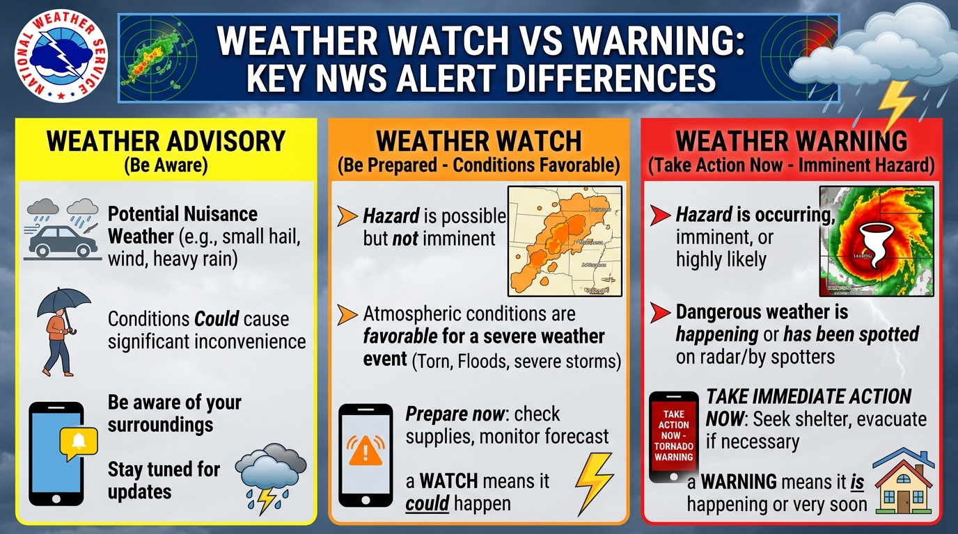
In the official National Weather Service (NWS) 3-tier system, a **Watch** means atmospheric ingredients are favorable for severe weather to develop later (Be Prepared); an **Advisory** means lesser weather hazards are occurring that cause travel inconvenience or caution (Be Aware); and a **Warning** means life-threatening or property-damaging severe weather is already occurring or imminent on radar (Take Action Immediately).
Interactive Weather Watch vs. Warning Decoder & Flood Water Vehicle Buoyancy Tool
1Watch vs. Advisory vs. Warning: The Official NWS 3-Tier Alert Hierarchy
During fast-moving severe weather outbreaks, confusing a **Watch** with a **Warning** can cost precious minutes of shelter time. To standardize emergency communication across all 50 states and 122 local Weather Forecast Offices (WFOs), the National Oceanic and Atmospheric Administration (NOAA) and National Weather Service (NWS) enforce a strict three-tier risk hierarchy based on certainty, timing, and severity.
1. **Weather Watch ('Be Prepared' — Conditions Are Favorable)**: A Watch is an advance planning alert issued when meteorological ingredients (such as wind shear, CAPE instability, or an approaching coastal cyclone) are coming together, meaning hazardous weather is *possible* but its exact timing and location remain uncertain. For convective hazards (Tornado Watch or Severe Thunderstorm Watch), the NOAA Storm Prediction Center (SPC) in Norman, Oklahoma issues watches covering tens of thousands of square miles for 4 to 8 hours. For winter storms, hurricanes, or floods, local NWS offices issue watches 12 to 48 hours in advance.
2. **Weather Advisory ('Be Aware' — Nuisance to Moderate Hazard Occurring)**: An Advisory is issued when hazardous weather is imminent or occurring with high certainty (80%+), but its intensity falls just below life-threatening warning criteria. Examples include a Winter Weather Advisory (typically 2 to 4 inches of snow or light icing causing slick commutes), a Wind Advisory (gusts of 45 to 57 mph), or a Heat Advisory.
3. **Weather Warning ('Take Action Now!' — Life-Threatening Hazard Imminent or Occurring)**: A Warning is the highest urgent operational alert. It means severe weather is already occurring—spotted by trained SKYWARN spotters or confirmed via Doppler radar—or will strike within minutes to a few hours. When a Tornado Warning, Severe Thunderstorm Warning (58+ mph winds or 1-inch+ hail), Hurricane Warning, or Flash Flood Warning is issued for your GPS polygon, you must execute protective shelter actions immediately.
- Tornado Watch vs. Tornado Warning: Watch = Check your safe room, keep shoes on, charge phones. Warning = Go to your basement or interior ground-floor room immediately.
- Severe Thunderstorm Criteria: Requires winds ≥ 58 mph and/or hail ≥ 1.00 inch (quarter size); triggers phone WEA alerts only if winds hit ≥ 80 mph or hail reaches ≥ 2.75 inches (baseball size).
- Storm-Based Polygons: Since 2007, NWS issues Tornado, Severe Thunderstorm, and Flash Flood Warnings for precise geographic polygons rather than entire counties, reducing false alarms by 70%.
2Beyond Standard Warnings: What Is a 'PDS Watch' and a 'Tornado Emergency'?
On rare, high-end outbreak days, standard Watch and Warning terminology is elevated with impact-based tags designed to cut through public complacency. When the Storm Prediction Center identifies an extraordinary atmospheric environment capable of producing multiple long-track, violent EF3 to EF5 tornadoes or 80–100+ mph derecho windstorms, forecasters attach the **'Particularly Dangerous Situation' (PDS)** wording to a Tornado Watch or Severe Thunderstorm Watch.
At the warning level, if a violent tornado is confirmed on the ground via Dual-Polarization Doppler radar debris signature ( a 'Tornado Debris Signature' or TDS showing lofted building materials) and is moving directly into a populated town or city, the local NWS office upgrades the Tornado Warning to a **Tornado Emergency**. A Tornado Emergency is the single highest convective alert in American meteorology and guarantees immediate, life-threatening structural destruction along the storm track.
3NWS Hazard Simplification Updates (2024–2027): Consolidated Cold & Flood Alerts
Under the multi-year NWS Hazard Simplification ('HazSimp') initiative completed across the 2024–2027 operational cycle, NOAA retired several confusing legacy advisories so the public can focus purely on Watch, Advisory, and Warning actions. For example, legacy 'Wind Chill Watches', 'Wind Chill Warnings', and 'Hard Freeze Warnings' were consolidated into straightforward **Extreme Cold Watches**, **Extreme Cold Warnings**, and **Cold Weather Advisories**—ensuring that dangerous cold is communicated clearly whether or not the wind is blowing.
Official National Weather Service (NWS) Watch vs. Advisory vs. Warning Comparison Matrix
| Alert Feature | Weather WATCH | Weather ADVISORY | Weather WARNING | EMERGENCY (PDS / Catastrophic) |
|---|---|---|---|---|
| Core Plain-English Meaning | Be Prepared: Ingredients are favorable | Be Aware: Caution needed for travel/outdoors | Take Action Now: Danger is imminent or occurring | Seek Immediate Survival Shelter: Catastrophic impact confirmed |
| Forecast Certainty | 30% to 70% Probability | 80%+ Certainty (Moderate Impact) | 80% to 100% Certainty (Severe Impact) | 100% Radar/Spotter Confirmed on Ground |
| Typical Lead Time | 4–8 hrs (Tornado) / 24–48 hrs (Winter/Hurricane) | 6 to 24 Hours | 15–45 mins (Tornado) / 12–36 hrs (Winter/Hurricane) | Minutes before impact |
| Geographic Area Covered | Multi-County / Regional (10,000–30,000 sq mi) | County or Forecast Zone | Precise Storm Track Polygon (100–500 sq mi) | High-Density Target Polygon |
| Triggers Phone WEA Siren? | No (Except Hurricane Watch in some apps) | No | Yes (Tornado, Hurricane, Extreme Cold, Major Flood/T-Storm) | Yes (Maximum Priority Override) |
4-Step Family & Workplace Action Plan for NWS Weather Alerts
Never Rely SOLELY on Outdoor Tornado Sirens Indoors
Outdoor civil defense sirens are designed only to warn people who are outdoors; they cannot penetrate modern insulated windows and heavy rain. Always keep a battery-backed NOAA Weather Radio and WEA-enabled smartphone by your bed.
During a WATCH: Stage Shoes, Helmets, Pet Carriers & Power Banks
When a Tornado or Severe Thunderstorm Watch is issued, put hard-soled shoes, bicycle helmets (for head protection), leashes, and backup batteries in your designated safe room.
During a WARNING: Move Immediately to the Lowest Interior Room
For Tornado or Destructive Thunderstorm (80+ mph) Warnings, move to a basement, storm shelter, or windowless ground-floor bathroom/closet immediately—never stay in a mobile home or vehicle.
Verify Your GPS Polygon on Radar Rather Than County Lines
Use weather.gov or a radar app displaying the red (Tornado), yellow (Severe Thunderstorm), or green (Flash Flood) NWS warning polygon to see if your exact street address is inside the threat box.
Curated Expert Video Walkthroughs & Wall Street Briefings



Frequently Asked Questions (Verified Statutory Answers)
Q1: Which is more serious: a Weather Watch or a Weather Warning?
A Weather Warning is far more urgent and serious. A Watch means severe weather is possible later today or tomorrow (be prepared), whereas a Warning means life-threatening weather is already occurring or about to hit your location within minutes (take shelter now).
Q2: What is the difference between a Winter Storm Warning and a Winter Weather Advisory?
A Winter Storm Warning is issued when heavy snow (typically 6+ inches in 12 hours, or 4+ inches in the South), heavy sleet, or crippling ice accumulation (≥ 0.25 inches) threatens life and property. A Winter Weather Advisory is issued for lighter snow (2 to 4 inches) or minor glaze icing that makes roads slippery but stays below major storm thresholds.
Q3: Why didn't my smartphone alarm go off during a Severe Thunderstorm Warning?
To prevent public alert fatigue, the National Weather Service only triggers loud Wireless Emergency Alerts (WEA) on mobile phones for 'Destructive' category Severe Thunderstorm Warnings—those packing hurricane-force wind gusts of 80+ mph or baseball-sized hail (2.75 inches or larger)—as well as all Tornado Warnings.
Q4: What does 'PDS' mean on a Tornado Watch?
PDS stands for 'Particularly Dangerous Situation'. The NOAA Storm Prediction Center adds this rare tag to less than 3% of Tornado Watches when atmospheric wind shear and instability support multiple long-track, violent EF3 to EF5 tornadoes.